Hikes of
La Gomera


Treks La Gomera
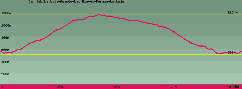
San Seb/La Laja-Agando-Las Nieves-Peraza-La Laja

Data sheet of the trail/hiking path 

1->2 - () Very good shape
 ->
->
 0,47 km
  26 m
26 m  43m
43m
From the end of the tarmac road in La Laja, descend the cement path towards 'Agando. Before reaching the houses, go down the stairs to the stream. Cross the bridge, climb to the flat below Pedro's house all the way up with very beautiful terrace walls. Further to the right the hike goes up towards los Roques (Agando) and straight towards Degollada de Peraza and the lower part of the village.
2->3 - () Very good shape
2,69 km 570 m 37m
Mount towards Agando (Los Roques) by the well-paved path. After entering a canopy of pines and eucaliptus (in the process of being eradicated) take a break at the casa del Manco , old forest house whose last tenant had only one arm, with an extraordinary view of los Roques.Continue climbing until you reach the main road (GM2) and GR131.This area was very affected by the great fires of 1984 and 2012. On the right the GR131 goes up towards Garajonay, on the left descends towards Las Nieves and San Sebastián.
3->4 - (GR 131) Very good shape
1,23 km 93 m 33m
Walk along the road a little and leave it in the direction of the Hermitage of Las Nieves and San Sebastián. Cross the forest of giant heathers before arriving at the Hermitage. From the square, the panorama over the entire south of the island and Playa Santiago in the background is absolutely irresistible. The place is equipped with tables, benches and shelters. Since the first inhabitants of the island, the place has always had a great cultural and religious importance, witnesses are the old sacrifice area and the chapel.
4->5 - (GR 131) Very good shape
2,06 km 7 m 186m
Down the tarmac road for 300m to the bend where the path resumes on the left (GR131/San Sébastien). down to the road and the Degollada de Peraza viewpoint.
5->6 - (GR 131) Very good shape
0,30 km 4 m 55m
Down some 200m by the path below the point of view in direction La Laja/San Sebastián, GR131.
6->7 - () Good shape
1,96 km 20 m 412m
Leaving the GR131 descend towards La Laja via a well-paved but steep path. Arrived at the hamlet, on the right the path descends towards the bottom of the valley then the paved road opposite, on the left it joins the upper part of the hamlet and Los Roques (Agando).
7->8 - () Very good shape
0,50 km 46 m 18m
Go up to the top of the village ( agando). The path, parallel to the road but on the other side of the valley is practically flat until the crossroads where on the one hand, on the left it goes up towards Agando, straight ahead, flat, it joins the highest houses of the village.
8->9 - () Very good shape
0,47 km 43 m 26m
Go up to the top of La Laja and follow until the last houses then find the end of the road which goes down again towards San Sébastien.
Feedback(0) 
Fotos de la ruta
Recommendation for hiking:
Consult previously the state of the hiking paths with the Cabildo