Hikes of
La Gomera


Treks La Gomera
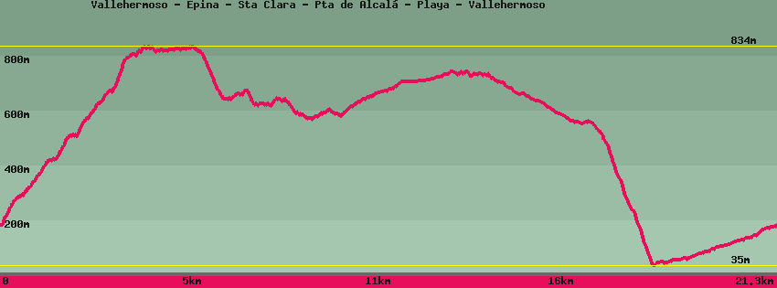
Vallehermoso - Epina - Sta Clara - Pta de Alcalá - Playa - Vallehermoso

Data sheet of the trail/hiking path 

1->2 - () Good shape
 ->
->
 4,36 km
  686 m
686 m  50m
50m
2->3 - () Good shape
0,93 km 19 m 5m
3->4 - () Good shape
0,24 km 3 m 18m
4->5 - () Very good shape
0,74 km 1 m 167m
5->6 - (GR 132) Very good shape
3,19 km 149 m 215m
6->7 - (GR 132) Very good shape
0,48 km 51 m 1m
Take in the direction of Tazo-Arguamul for a few meters to find the path that descends in front of the sheepfold towards Epina to a small palm grove. On the right a path joins the village of Tazo, straight ahead it continues on Epina.
7->8 - (GR 132) Dirt road
2,57 km 121 m 17m
Continue on the track towards Epina-Tazo. At the junction with the track which arrives on the left from Epina and continues on the right towards Tazo-Arguamul is a building which was used to gather herds.
8->9 - (GR132) Very good shape
1,62 km 36 m 111m
Follow the path which passes by a place equipped for picnics on the left of the chapel. The view of the seaside and the tip of Arguamul is impressive. If the weather is clear you can see the island of La Palma in the distance. The forest then gives way to more arid terrain before emerging on a track dominated by a structure of nets intended to collect the water brought by the trade winds. Below we can see the rock of Los Organos which can only be appreciated from the sea. borders the creek. Follow the track in the middle of the garden along the stream and in the shade of the palm trees. The Botanical Garden is on the edge and a small wooden bridge provides access.
Continue to the road where you can reach it by a staircase.
9->10 - (GR132) Dirt road
1,67 km 2 m 111m
Continue on the track in the middle of ocher land furrowed by erosion. The hermitage of Coromoto is in the middle of the hike which arrives at the end of the cliff from where you can see the whole northwestern part of the island as well as the Teide in the distance on the sea and La Palma if weather permitting.
10->11 - () Dirt road
0,16 km 10 m 5m
Climb up to the watchtower to take full advantage of the panorama. Go back down.
11->12 - () Dirt road
0,16 km 5 m 10m
Go back down the dirt track.
12->13 - (GR 132) Very good shape
1,87 km 0 m 517m
Descend by the GR132 in the direction of Vallehermoso beach. The descent is quite steep but the view magnificent with vegetation marked by Sabinas and cardoncillos. Arrived on the road, a driveway back to the beach allows you to enjoy the marine atmosphere and contemplate the old banana pier which allowed their export in the 1940s. from the church. Further down at the crossroads, go up towards the church on the left. From the church go up and follow to the cemetery. On the left the GR132.
13->14 - () Dirt road
2,84 km 136 m 7m
Go up the road for 1 km and at the bus shelter turn right for a few meters to take the dirt track which borders the stream. Follow the track in the middle of the garden along the stream and in the shade of the palm trees. The Botanical Garden is on the edge and a small wooden bridge provides access.
Continue to the road where you can reach it by a staircase.
14->15 - () Road
0,41 km 18 m 0m
Walk up the street in front of the bus station to reach the center of the village.
Feedback(0) 
Fotos de la ruta
Recommendation for hiking:
Consult previously the state of the hiking paths with the Cabildo