Hikes of
La Gomera


Treks La Gomera
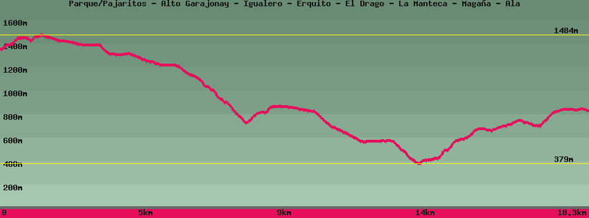
Parque/Pajaritos - Alto Garajonay - Igualero - Erquito - El Drago - La Manteca - Magaña - Ala

Data sheet of the trail/hiking path 

1->2 - (GR 131) Very good shape
 ->
->
 0,58 km
  112 m
112 m  7m
7m
In front of the Pajaritos car park, cross the roundabout and take the track indicated alto de Garajonay for a few meters . Leave it on the right towards el Alto de Garajonay then climb through the heather. Arrived on a flat on the right a path descends towards the parking lot of the Contadero. Straight towards the summit (Alto de Garajonay).
2->3 - (GR 131) Very good shape
0,16 km 17 m 2m
Follow towards the summit in the middle of low vegetation resulting from the fire of 2012 and go down again until the crossing on the right towards the Contadero, on the left towards Igualero and all straight towards the summit (Alto de Garajonay.
3->4 - (GR 131) Very good shape
0,08 km 0 m 12m
Go up to the top of Garajonay. On the opposite side of the esplanade, a cemented track goes down to the Contadero parking lot.
4->5 - (GR 131) Very good shape
0,28 km 40 m 0m
5->6 - (GR 131) Dirt road
0,53 km 0 m 52m
Go down the cement track towards Contadero. Further down is a crossroads. On the left, a dirt track joins Chipude and El Cercado, a path on the right returns to the summit of Garajonay and the cement track continues downhill towards the Contadero.
6->7 - (GR 131) Dirt road
1,24 km 7 m 43m
7->8 - (GR 131) Very good shape
0,83 km 12 m 88m
8->9 - (GR 131) Very good shape
0,90 km 0 m 80m
9->10 - () Very good shape
0,36 km 1 m 22m
10->11 - () Very good shape
0,44 km 8 m 33m
11->12 - () Very good shape
2,13 km 4 m 469m
12->13 - () Very good shape
0,30 km 76 m 0m
13->14 - () Very good shape
1,77 km 78 m 54m
14->15 - () Very good shape
1,41 km 3 m 266m
15->16 - () Very good shape
0,72 km 10 m 7m
16->17 - () Very good shape
1,07 km 8 m 187m
17->18 - (GR 132) Very good shape
0,69 km 55 m 24m
18->19 - (GR 132) Very good shape
0,97 km 193 m 9m
19->20 - (GR 132) Very good shape
2,17 km 171 m 74m
20->21 - (GR 132) Very good shape
1,70 km 156 m 30m
Feedback(0) 
Fotos de la ruta
Recommendation for hiking:
Consult previously the state of the hiking paths with the Cabildo