Hikes of
La Gomera


Treks La Gomera
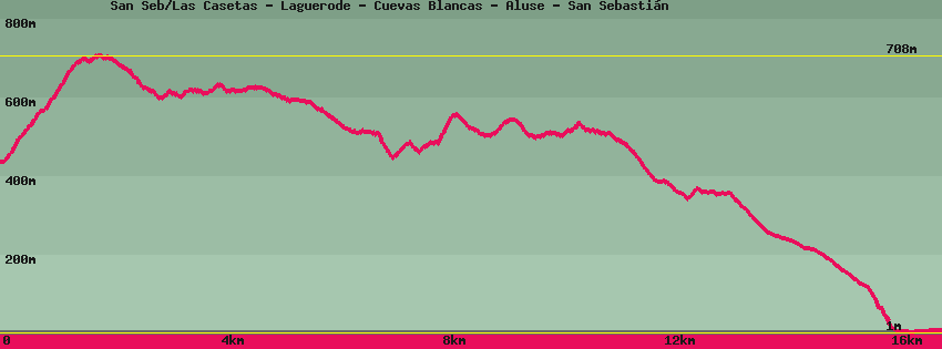
San Seb/Las Casetas - Laguerode - Cuevas Blancas - Aluse - San Sebastián

Data sheet of the trail/hiking path 

1->2 - () Very good shape
 ->
->
 1,58 km
  266 m
266 m  1m
1m
From the place called Las Casetas (km8 on the GM1), the path, after a few meters, leaves the cement track on the left (Ruta 31 Enchereda/Cuevas Blancas) to pass above the beehives and climbs towards the ridge where we find the GR132 which comes, on the right, from San Sebastien and continues on Hermigua, on the left.
2->3 - (GR 132) Very good shape
1,23 km 18 m 117m
Let's take the GR132 in the direction of San Sebastien towards the East. The hike follows the ridge, bordering the natural part of Majona. The Canarian pines testify to the wind that can blow on these heights. Let's go back down on the track.
3->4 - (GR 132) Very good shape
0,15 km 12 m 5m
4->5 - () Very good shape
0,85 km 69 m 44m
Leave the GR132 by the balcony path which continues on the same slope. After crossing a pine forest of Canarian pines we come out on the Barranco de Cheremía like a huge amphitheater.
5->6 - () Very good shape
0,88 km 19 m 39m
Walk along the abandoned house with its old oven then descend slightly on the western slope of the valley whose terraces were once planted with cereals and form an immense amphitheater. Arriving on the plateau, a poorly signposted path descends to the right towards the bottom of the valley. Straight on the village of Cuevas Blancas.
6->7 - () Very good shape
1,11 km 2 m 79m
Continue on Cuevas Blancas. The hike continues on the western edge of the valley once planted with cereals. Follow the balcony path which, after changing sides, borders the Barranco de Majona and brings us to the abandoned village of Cuevas Blancas. On the left, at the first house, the path begins that descends into the Barranco de Majona, on the right it continues, below the troglodyte village, towards San Sébastien or Jaragán.
7->8 - () Very good shape
2,02 km 170 m 145m
Continue below the village, then along the caves which served as shelter for the animals of the village. Volcanic rocks explode into colors and shapes. After the pass and then the barranco de Zamora and an old place of arboreal settlement, the path goes up on the Cheremía strip. From the flat, a path goes up to the right and joins the one at the top of the valley. Straight down to the bottom of the valley and San Sebastián.
8->9 - () Very good shape
1,85 km 73 m 114m
Descend towards the bottom of the valley and the small palm grove which is there with a source. Cross the barranco and go up to follow the northeast side of the mountain until you find the GR132. On the left it continues towards San Sebastián and on the right it goes up towards Jaragán then Hermigua (note this crossing is not signposted and can go unnoticed).
9->10 - (GR 132) Very good shape
2,04 km 35 m 211m
Follow towards San Sébastien until you reach a pass from which you overlook the Molinito district and the hospital.
10->11 - (GR 132) Very good shape
4,30 km 38 m 373m
Continue towards San Sebastien, going up a stone ramp slightly. The descent to the first house of the Gallarda is easy. After the roundabout, go straight down the street towards the port.
Description
La randonnée est trés agréable et peut se faire en utilisant le bus: descendre au lieu-dit Las Casetas. La vue sur le barranco de Majona est magnifique avec en fond la mer et l'île de Ténérife dominé por les 3 718m du volcan du Teide. En hiver le sommet peut-être enneigé. Les paysages sont très variés et le village de Cuevas Blancas, anciennes maisons troglodytes, est un vestige d'une époque où La Gomera exportait ses récoltes de céréales.
Feedback(0) 
Fotos de la ruta
Recommendation for hiking:
Consult previously the state of the hiking paths with the Cabildo