Hikes of
La Gomera


Treks La Gomera
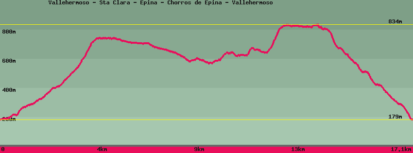
Vallehermoso - Sta Clara - Epina - Chorros de Epina - Vallehermoso

Data sheet of the trail/hiking path 

1->2 - () Very good shape
 ->
->
 4,55 km
  572 m
572 m  16m
16m
From Vallehermoso square, take the street that goes up to the right of the Central café, and then go up the Valle gran Rey road to the Cuartel de la guardia civil. Then turn towards the cemetery and just before it go down the path towards Santa Clara, cross the bridge and then go up the barranco de La Era Nueva, formerly Barranco de los Franceses. After a section in the middle of euhorbia, sagebrush, the low-growing vegetation characteristic of medium-altitude areas gives way to fayal brezal which borders the forest. After passing through the forest, the path leads to the hermitage of Santa Clara.
2->3 - (GR 132) Dirt road
2,57 km 17 m 121m
Continue on the track towards Epina until you reach an old sheepfold located at the crossing with the dirt track coming on the left from Épina and on the right from Tazo and Arguamul.
3->4 - (GR 132) Very good shape
0,48 km 1 m 51m
Take the track towards Tazo / Arguamul for a few meters to the start of the path which descends towards a palm grove where it divides into 2 parts: on the right Tazo and straight on Épina.
4->5 - (GR 132) Very good shape
3,19 km 215 m 149m
Let's continue towards Épina on the western side of the island with an alternation of more green and dry depending on the orientation. On arrival in the village, there is a ruin below the path, then a small path descends to the right. Straight ahead, the path bypasses the village
5->6 - () Very good shape
0,74 km 167 m 1m
6->7 - () Good shape
0,24 km 18 m 3m
7->8 - () Good shape
0,93 km 5 m 19m
8->9 - () Good shape
4,36 km 50 m 686m
Feedback(0) 
Fotos de la ruta
Recommendation for hiking:
Consult previously the state of the hiking paths with the Cabildo