Hikes of
La Gomera


Treks La Gomera
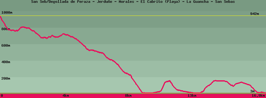
San Seb/Degollada de Peraza - Jerduñe - Morales - El Cabrito (Playa) - La Guancha - San Sebas
 - La Guancha - San Sebas")
Data sheet of the trail/hiking path 

1->2 - () Very good shape
 ->
->
 1,62 km
  90 m
90 m  231m
231m
2->3 - () Very good shape
2,46 km 117 m 198m
The old road goes around a promontory on which there is a house. The path starts in the curve towards Seima/Morales and Casas Contreras. Pass the few houses below and continue down to the troglodyte houses of Tacalcuse. Go up on the plateau opposite where the hike splits, left towards Seima/Morales and El Cabrito, right towards Casas Contreras and Playa Santiago.
3->4 - () Very good shape
1,73 km 9 m 207m
Head towards Seima/Morales and El Cabrito. Cross the Seima plateau, once the island's grain granary. In the abandoned village of Casas Contreras, in the middle of the houses, find the GR132 which continues straight towards Cabrito and San Sebastian and on the right towards Casas Contreras and Playa Santiago.
4->5 - (GR 132) Very good shape
1,12 km 3 m 110m
5->6 - (GR 132) Very good shape
2,70 km 5 m 416m
6->7 - (GR 132) Very good shape
1,26 km 156 m 9m
7->8 - (GR 132) Very good shape
1,73 km 2 m 149m
Go back down on the barranco of La Guancha towards San Sebastian. An old fisherman's house is opposite the pebble beach. On the right of the beach there is a bit of sand. There is a gently sloping well on the beach where the shepherd who once kept his goats there watered them.
8->9 - (GR 132) Very good shape
1,92 km 154 m 33m
Go up on the plateau towards San Sebastian then go down to the power station.
9->10 - (GR 132) Very good shape
0,85 km 52 m 43m
10->11 - (GR 132) Very good shape
1,47 km 7 m 133m
Feedback(0) 
Fotos de la ruta
Recommendation for hiking:
Consult previously the state of the hiking paths with the Cabildo