Hikes of
La Gomera


Treks La Gomera
Vallehermoso/Chorros de Epina - Epina - Tazo - Playa del Trigo - Alojera - Chorros de Epina

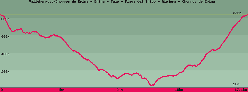
Data sheet of the trail/hiking path 

1->2 - () Good shape
 ->
->
 0,24 km
  3 m
3 m  18m
18m
2->3 - () Very good shape
0,74 km 1 m 167m
3->4 - (GR 132) Very good shape
3,19 km 149 m 215m
4->5 - (Gr132) Very good shape
1,51 km 1 m 208m
5->6 - () Very good shape
2,97 km 84 m 303m
6->7 - () Dirt road
0,90 km 31 m 25m
7->8 - () Very good shape
0,96 km 8 m 143m
8->9 - () Very good shape
1,27 km 127 m 19m
9->10 - () Good shape
0,46 km 14 m 6m
10->11 - () Good shape
0,85 km 114 m 0m
11->12 - (GR 132) Good shape
2,83 km 422 m 42m
12->13 - (GR 132) Good shape
0,54 km 116 m 0m
13->14 - (GR 132) Good shape
0,42 km 72 m 10m
14->15 - () Good shape
0,24 km 18 m 3m
Feedback(0) 
Fotos de la ruta
Recommendation for hiking:
Consult previously the state of the hiking paths with the Cabildo