Hikes of
La Gomera


Treks La Gomera
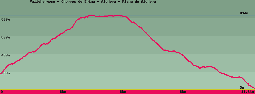
Vallehermoso - Chorros de Epina - Alojera - Playa de Alojera

Data sheet of the trail/hiking path 

1->2 - () Good shape
 ->
->
 4,36 km
  686 m
686 m  50m
50m
2->3 - () Good shape
0,93 km 19 m 5m
3->4 - () Good shape
0,24 km 3 m 18m
4->5 - (GR 132) Good shape
0,42 km 10 m 72m
5->6 - (GR 132) Good shape
0,54 km 0 m 116m
6->7 - (GR 132) Good shape
2,83 km 42 m 422m
Keep going down and cross the road several times. After passing water reservoirs for watering, the descent continues to the first houses and then the road. Follow the road and turn left to go up towards the church. On the left side of the church the street goes down to Alojera beach, completely on the left it goes up to Taguluche and Arure.
7->8 - () Good shape
0,85 km 0 m 114m
8->9 - () Good shape
0,46 km 6 m 14m
9->10 - () Good shape
0,69 km 3 m 135m
Feedback(0) 
Fotos de la ruta
Recommendation for hiking:
Consult previously the state of the hiking paths with the Cabildo