Hikes of
La Gomera


Treks La Gomera
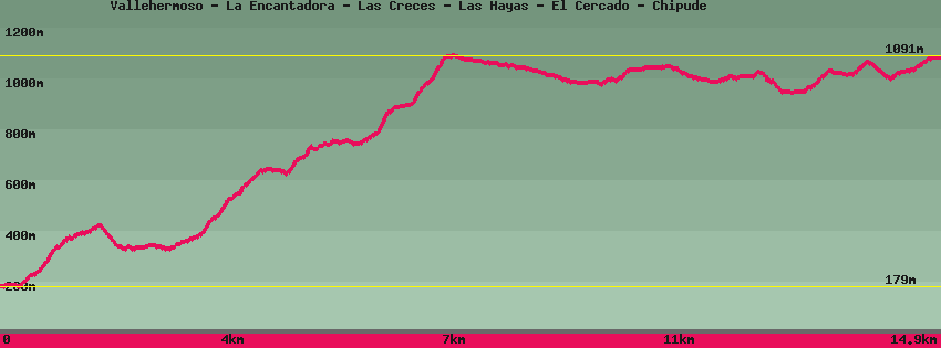
Vallehermoso - La Encantadora - Las Creces - Las Hayas - El Cercado - Chipude

Data sheet of the trail/hiking path 

1->2 - (GR 131) Very good shape
 ->
->
 2,77 km
  302 m
302 m  141m
141m
2->3 - (GR 131) Very good shape
0,16 km 18 m 2m
3->4 - (GR 131) Road
0,28 km 32 m 0m
4->5 - (GR 131) Very good shape
0,78 km 193 m 3m
5->6 - (GR 131) Very good shape
1,79 km 242 m 77m
6->7 - (GR 131) Very good shape
1,20 km 277 m 3m
7->8 - (GR 131) Very good shape
0,71 km 76 m 24m
8->9 - (GR 131) Very good shape
0,57 km 12 m 37m
From the Las Creces parking area, take the track that goes deep into the forest to an old clearing for recreation. In this the forest track, on the right the path.
9->10 - () Very good shape
1,01 km 5 m 67m
Follow the path towards Arure or Las Hayas inside the forest. The path, very pleasant, is practically flat. Junction for Arure on the right or Las Hayas on the left,
10->11 - () Very good shape
0,91 km 65 m 11m
Continue towards Las Hayas until you find a forest track. Opposite Las Hayas, on the right the fields.
11->12 - (GR 131) Very good shape
0,80 km 14 m 45m
Follow the GR131 in the middle of the giant heathers which form a rather phantasmagoric setting. The exit from the forest is above the chapel. Go straight down to the road and the next crossing at the level of the large eucaliptus trees in front of the Efigenia bar-restaurant. left direction Valle Gran Rey-San Sebastien, right Arure. GR131.
12->13 - (GR 131) Very good shape
1,00 km 46 m 26m
Take the direction of Valle Gran Rey-San Sébastien and follow this section of paved road to the next ridge, cross the road and resume the path opposite in the direction of Valle Gran Rey-San Sebastien. On the next ridge another crossing: left towards Valle Gran Rey/Los Descansaderos, opposite El Cercado/Chipude/San Sébastien. GR131.
13->14 - (GR 131) Very good shape
1,16 km 99 m 92m
Continue the GR131 towards El Cercado which can be seen on the plateau opposite. The path goes around the canyon of Valle Gran Rey that can be seen at the bottom of the valley. Go up to El Cercado, known for its traditional pottery, at the María bar. Turn right towards Valle Gran Rey/La Viscaina, opposite the potteries, Chipude/San Sébastien, Valle Gran Rey/Chele/Gerian.
14->15 - (GR 131) Very good shape
1,76 km 137 m 91m
Follow the road towards Chipude and pass in front of the potters' shops. At the bend go down the stairs and follow the road. Go up towards Chipude leaving on the right the path which descends towards La Matanza and Valle Gran Rey. Follow the markings to the central square of Chipude.
Feedback(0) 
Fotos de la ruta
Recommendation for hiking:
Consult previously the state of the hiking paths with the Cabildo