Hikes of
La Gomera


Treks La Gomera
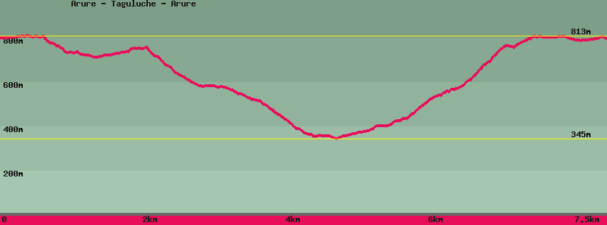
Arure - Taguluche - Arure

Data sheet of the trail/hiking path 

1->2 - (GR 132) Very good shape
 ->
->
 2,52 km
  98 m
98 m  316m
316m
Follow the GR132, lined with pine trees, on the left of the chapel at the end of the 'Mirador del Santo' square. At 100m leave on the left a path which descends steeply to Taguluche (camino de los pasos). Follow the contour along the Lomo del Carretón. This part is not recommended in strong winds or rain because of rock falls that may occur. The descent to the paved road is on a ridge. 50m after the electricity pylon and before the road, a path heads off to the left towards Taguluche; the GR 132 continues on the ridge towards Alojera.
2->3 - () Very good shape
1,66 km 29 m 262m
Take the path towards Taguluche which runs along the road above it, which it crosses before going along the cemetery. Before joining the road at the level of the water tank on the left an old dirt track descends towards the terraces and the road below, straight ahead the tarmac road goes up to the top of the village or down to the bottom of it .
3->4 - () Very good shape
0,40 km 42 m 0m
Go up the village on the road to a house in the hairpin bend. On the left a path goes down towards the village and the beach, opposite on the hill, it goes up towards Valle Gran Rey by los Pasos or La Merica.
4->5 - () Very good shape
0,41 km 53 m 7m
Direction Valle Gran Rey, pass on the side of the hill (or by the entrance of the house leaves the path), go straight up to a group of houses, before this one, a cement path (white) goes to the right, another continues to go straight up (camino de los Pasos). Turn right in front of the house and follow the cemented, flat path. After the water reservoir and before the white house, take the path on the left and pass above the house. Cross the bed of the stream and arrive at a small group of palm trees from where, on the right, a path goes down towards Taguluche, straight towards Valle Gran Rey and Arure (no signage).
5->6 - () Very good shape
1,72 km 401 m 28m
Go up towards Arure. Very quickly the slope becomes steeper and the course continues all in laces along the cliff until its exit on the plateau where it meets the track (GR132) coming from Arure on the left and Valle Gran Rey-La Merica on the right.
6->7 - (GR 132) Dirt road
0,83 km 23 m 34m
Follow the track (GR132) towards Arure and go up towards the Mirador del Santo (GR132).
Feedback(0) 
Fotos de la ruta
Recommendation for hiking:
Consult previously the state of the hiking paths with the Cabildo