Hikes of
La Gomera


Treks La Gomera
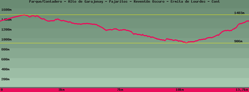
Parque/Contadero - Alto de Garajonay - Pajaritos - Reventón Oscuro - Ermita de Lourdes - Cont

Data sheet of the trail/hiking path 

1->2 - () Dirt road
 ->
->
 0,40 km
  39 m
39 m  0m
0m
2->3 - () Dirt road
0,43 km 41 m 0m
3->4 - (GR 131) Dirt road
0,53 km 52 m 0m
4->5 - (GR 131) Very good shape
0,28 km 0 m 40m
5->6 - (GR 131) Very good shape
0,08 km 12 m 0m
6->7 - (GR 131) Very good shape
0,16 km 2 m 17m
7->8 - (GR 131) Very good shape
0,58 km 7 m 112m
8->9 - (GR 131) Very good shape
1,17 km 57 m 80m
9->10 - (GR 131) Very good shape
2,15 km 40 m 206m
10->11 - () Very good shape
1,61 km 58 m 136m
Enter the forest towards of Reventón Oscuro. The path follows and then turns away from the road with a superb view of Los Roques. With luck you can see Raviche pigeons (they are rather on the edge of the forest). Leave the forest at Reventón Oscuro from where the paved track starts towards Cedro. Straight on el Baladero.
11->12 - () Very good shape
1,26 km 27 m 124m
12->13 - () Good shape
0,37 km 4 m 30m
13->14 - () Good shape
0,75 km 19 m 78m
Descend the paved track and leave the dirt track on the left that leads to las Mimbreras near the Cedro Hermitage. A little further down, in the bend, on the left at the level of a recess for parking, the path begins which leads to the Ermita de Ntra Sra de Lourdes.
14->15 - () Very good shape
0,46 km 29 m 2m
Follow the stream in the forest to Las Mimbreras and exit at the car park along the track which on the left leads to the paved track of Cedro and on the right reaches the village of Los Aceviños . After the bridge, on the left, the path starts that goes up to the summit of Garajonay.
15->16 - () Very good shape
0,63 km 52 m 0m
16->17 - () Very good shape
2,46 km 389 m 22m
Feedback(0) 
Fotos de la ruta
Recommendation for hiking:
Consult previously the state of the hiking paths with the Cabildo