Geology
Climate - Ressources - Culture - Histoire - Nature - Garajonay National Park - Protected areas
Fauna - Flora - Geology - Silbo Gomero
The island of La Gomera is a volcanic structure without any eruption in the last 2 millions of years.
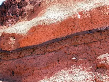
 Piles of lavaIt has been formed by the accumulation of rocks originated in multiple eruptions, rising about 5,500 m from the bottom of the ocean. The island has not undergone any recent volcanic activity, and the erosion of running water has excavated a radial network of deep ravines. The erosion of the sea has eaten away much of the coast, carving out cliffs of considerable height.
The Basal Complex is the oldest of the two great geological units that comprise the island. They are submarine rocks formed when the island had not yet emerged from the sea and the eruptions occurred under the ocean. Its age oscillates between 20 and 12 million years, and a great number of dikes run through the rocks.
 The Basal Complex underwent a vertical shift and was elevated above sea level, and thereby subjected to an intense erosion during a period of volcanic inactivity. Presently only the rocks in the north rise from the water.
At some places, such as the coast of Arguamul, the so-called pillow lavas, of submarine origin, are visible.
The volcanic eruptions produced above sea level began again 10 million years ago, forming the other geological unit of the island, the Volcanic Series. This unit is constituted by piles of lava of great thickness and volcanic cones of basalt, and gives rise to two series, the lower or Ancient Basalt (of between 10 and 6 million years), and the upper or Horizontal Basalt (of between 5 and 2.8 million years). One excellent observation point for the contact between these two series is the lookout point at Palmarejo (Valle Gran Rey).
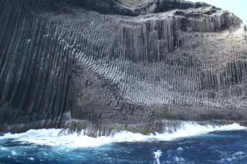
 The piles of lavas from these series were later run through by great masses of magma, which on cooling in the depths of the earth gave rise to domes of phonolytic rocks of highly varied forms. Erosion has left these subterranean structures bare, which, being harder than the surrounding materials, stand out in the landscape, forming impressive rocks like those of Agando, Ojila, the Zarcita, Roque Cano, Los Organos and La Fortaleza.
PageTop


