Hikes of
La Gomera


Treks La Gomera
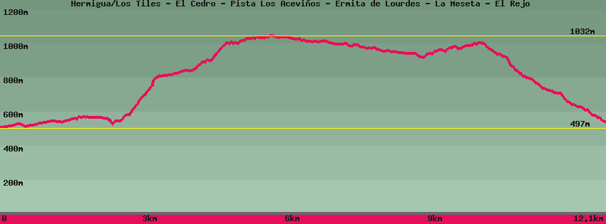
Hermigua/Los Tiles - El Cedro - Pista Los Aceviños - Ermita de Lourdes - La Meseta - El Rejo

Data sheet of the trail/hiking path 

1->2 - () Dirt road
 ->
->
 2,20 km
  112 m
112 m  70m
70m
From the main road GM1, above the Mulagua dam, take the track that leads to the los Tiles dam. This is the first track after the Rejo curve which follows the junction of the Cedro road. Follow the track to the dam.
2->3 - () Very good shape
1,31 km 306 m 31m
Go up along the dam in the direction of Cedro. The waterfall that descends from a height of more than 200m marks the entire landscape and brings water to the exuberant vegetation found there. The climb is steep but the landscape is absolutely beautiful until you reach the plateau. Follow the stream to the picnic area. (Alternative: go up directly opposite the sheep shelter by the stairs to the La Vista bar)
3->4 - () Very good shape
1,32 km 207 m 35m
Go up to the La Vista bar and continue the higher track. Just after entering a property with a house, the dirt path goes up along a green fence, then at the end of it, climbs to the right to enter the forest. Follow in the forest until the arrival on a track. On the left, a little hidden, a few meters before arriving on the track, a path goes up to the main track from Cedro to Los Aceviños which is also reached by following the track to the left, on the right it goes down to Los Aceviños and Hermigua.
4->5 - () Very good shape
0,13 km 23 m 0m
Go up the path to reach the upper track. On the left Las Mimbreras and the Hermitage of Lourdes, on the right Los Aceviños.
5->6 - () Very good shape
2,95 km 134 m 210m
Follow the track towards Las Mimbreras and the Ermita de Lourdes to a place called Las Mimbreras. Flat and easy course of 3km. At las Mimbreras, before the bridge, a hiking trail goes up on the right to a place called El Contadero and the summit of Garajonay. After the bridge and from the car park, the path descends to the left towards the chapel of Nuestra Señora de Lourdes. Straight on, the track joins the road that descends from Reventón Oscuro towards the hamlet of Cedro.
6->7 - () Very good shape
0,46 km 2 m 29m
Go down towards the chapel of Nuestra Señora de Lourdes. The path follows the stream, then a small wooden bridge allows you to cross it to reach the chapel. In front of it, on the right, the 'policy path' leads to the paved Cedro road. Straight on the path continues to descend towards the hamlet of Cedro.
7->8 - () Good shape
0,75 km 78 m 19m
Leave the main path and go up the one that goes in front of the chapel. Some call it 'the policy path'. Follow until you come out on a cemented and paved track. Go up the paved track for a few hundred meters to a very tight curve from which 2 paths depart: on the left downhill towards the Aula de la Naturaleza and El Cedro, opposite downhill towards La Meseta and Hermigua. The track continues on the right towards the Reventón Oscuro.
8->9 - () Good shape
0,37 km 30 m 4m
9->10 - () Very good shape
1,07 km 4 m 205m
Descend in the direction of La Meseta-Hermigua. At the end of the route follow and cross the canal then descend on a path which leads, on the left, to a tunnel which joins the hamlet of Cedro (the canal is passable with light and with your feet in the water, 15 to 20 minutes , 1.70m in height). Follow to the right until the paved road. Descend to the chestnut trees, from where on the left a path descends towards the houses of La Meseta.
10->11 - () Very good shape
1,58 km 10 m 266m
Follow the road for a hundred meters and at the car park under the chestnut tree, go down towards the houses of La Meseta in the middle abandoned terraces. The path turns into a track to arrive at a place with a niche: the Ermita de Guadalupe. Leave the track by the path, in the direction of Hermigua-El Rejo, which goes down to some waterfalls. A route has been made in wood to discover this somewhat magical place. Continue down the path along the stream, the terraces and some waterfalls. Do not hesitate to waste some time to go see them. The path leads to the road to Hermigua at a place called El Rejo.
Feedback(0) 
Fotos de la ruta
Recommendation for hiking:
Consult previously the state of the hiking paths with the Cabildo