Hikes of
La Gomera


Treks La Gomera
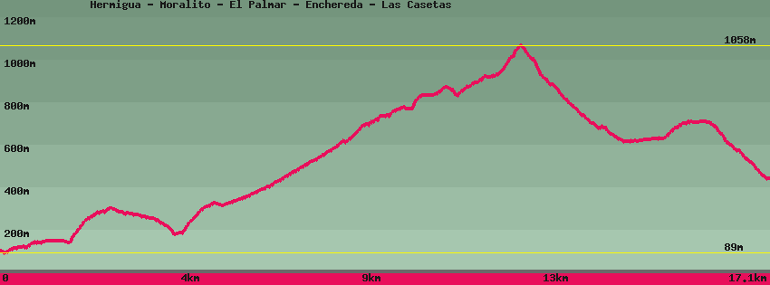
Hermigua - Moralito - El Palmar - Enchereda - Las Casetas

Data sheet of the trail/hiking path 

1->2 - () Road
 ->
->
 0,77 km
  51 m
51 m  14m
14m
2->3 - () Road
0,45 km 6 m 1m
3->4 - () Road
0,29 km 2 m 8m
4->5 - () Very good shape
0,55 km 35 m 37m
5->6 - () Dirt road
0,60 km 5 m 26m
Follow the dirt track bordered by the drinking water supply pipe. On the left descends a dirt track towards the houses of Moralito that can be seen at the bottom of the valley. The track continues towards Montoro and El Palmar.
6->7 - () Very good shape
0,60 km 8 m 81m
Go down the track towards the houses of Moralito. Cross the bed of the stream and arrive at the 2nd house.
7->8 - () Very good shape
0,52 km 119 m 9m
Climb from El Moralito in the direction of Palmar towards the east. Arrived on the ridge the path on the left allows you to reach La Caleta directly, on the right it goes up to join the track.
8->9 - () Very good shape
0,28 km 34 m 0m
Go up to join the track. To the right Hermigua and to the left El Palmar or San Sébastien
9->10 - () Dirt road
0,21 km 0 m 15m
Continue towards El Palmar. Further on the track splits on the right towards San Sébastien and on the left towards El Palmar.
10->11 - () Dirt road
0,97 km 87 m 0m
11->12 - (GR 132) Dirt road
2,70 km 370 m 36m
12->13 - () Good shape
4,97 km 398 m 520m
13->14 - (GR 132) Dirt road
0,88 km 20 m 3m
14->15 - (GR 132) Very good shape
0,97 km 86 m 10m
15->16 - () Very good shape
1,58 km 1 m 266m
Descend towards Las Casetas and the main road GM1. Arrived at Las Casetas, after crossing the road, the path continues towards El Atajo and San Sebastian.
Feedback(0) 
Fotos de la ruta
Recommendation for hiking:
Consult previously the state of the hiking paths with the Cabildo