Hikes of
La Gomera


Treks La Gomera
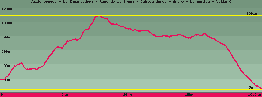
Vallehermoso - La Encantadora - Raso de la Bruma - Cañada Jorge - Arure - La Merica - Valle G

Data sheet of the trail/hiking path 

1->2 - (GR 131) Very good shape
 ->
->
 2,77 km
  302 m
302 m  141m
141m
2->3 - (GR 131) Very good shape
0,16 km 18 m 2m
3->4 - (GR 131) Road
0,28 km 32 m 0m
4->5 - (GR 131) Very good shape
0,78 km 193 m 3m
5->6 - (GR 131) Very good shape
1,79 km 242 m 77m
6->7 - (GR 131) Very good shape
1,20 km 277 m 3m
7->8 - () Very good shape
0,64 km 86 m 39m
8->9 - () Very good shape
0,79 km 3 m 98m
9->10 - () Dirt road
1,26 km 4 m 85m
10->11 - () Very good shape
1,67 km 24 m 113m
11->12 - () Very good shape
0,73 km 18 m 16m
12->13 - (GR 132) Dirt road
0,83 km 34 m 23m
Pass under the arch and go down the stone ramp then turn right in the direction of Valle Gran Rey (GR132). Follow the track. Once arrived on a flat with some terraces a path goes on the right towards Taguluche we lose the view on the barranco and the sea. The track (GR132) continues towards Valle Gran Rey-La Merica.
13->14 - (GR 132) Very good shape
6,57 km 131 m 896m
Continue on the track towards Valle Gran Rey and cross the plain of La Mérica, an old place of cereal cultivation with its old lime kilns. Arrived at the edge of the cliff descend by a winding path towards Valle Gran Rey and the district of La Calera. Continue down a street that ends in stairs that join the taxi rank and the town hall on the main road.
Feedback(0) 
Fotos de la ruta
Recommendation for hiking:
Consult previously the state of the hiking paths with the Cabildo