Hikes of
La Gomera


Treks La Gomera
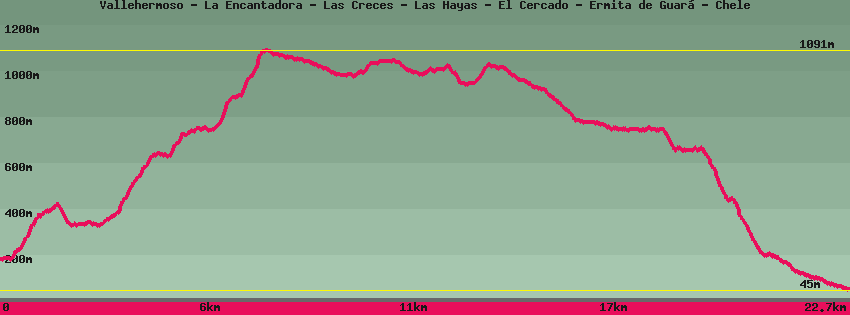
Vallehermoso - La Encantadora - Las Creces - Las Hayas - El Cercado - Ermita de Guará - Chele

Data sheet of the trail/hiking path 

1->2 - (GR 131) Very good shape
 ->
->
 2,77 km
  302 m
302 m  141m
141m
2->3 - (GR 131) Very good shape
0,16 km 18 m 2m
3->4 - (GR 131) Road
0,28 km 32 m 0m
4->5 - (GR 131) Very good shape
0,78 km 193 m 3m
5->6 - (GR 131) Very good shape
1,79 km 242 m 77m
6->7 - (GR 131) Very good shape
1,20 km 277 m 3m
7->8 - (GR 131) Very good shape
0,71 km 76 m 24m
8->9 - (GR 131) Very good shape
0,57 km 12 m 37m
From the Las Creces parking area, take the track that goes deep into the forest to an old clearing for recreation. In this the forest track, on the right the path.
9->10 - () Very good shape
1,01 km 5 m 67m
Follow the path towards Arure or Las Hayas inside the forest. The path, very pleasant, is practically flat. Junction for Arure on the right or Las Hayas on the left,
10->11 - () Very good shape
0,91 km 65 m 11m
Continue towards Las Hayas until you find a forest track. Opposite Las Hayas, on the right the fields.
11->12 - (GR 131) Very good shape
0,80 km 14 m 45m
Follow the GR131 in the middle of the giant heathers which form a rather phantasmagoric setting. The exit from the forest is above the chapel. Go straight down to the road and the next crossing at the level of the large eucaliptus trees in front of the Efigenia bar-restaurant. left direction Valle Gran Rey-San Sebastien, right Arure. GR131.
12->13 - (GR 131) Very good shape
1,00 km 46 m 26m
Take the direction of Valle Gran Rey-San Sébastien and follow this section of paved road to the next ridge, cross the road and resume the path opposite in the direction of Valle Gran Rey-San Sebastien. On the next ridge another crossing: left towards Valle Gran Rey/Los Descansaderos, opposite El Cercado/Chipude/San Sébastien. GR131.
13->14 - (GR 131) Very good shape
1,16 km 99 m 92m
Continue the GR131 towards El Cercado which can be seen on the plateau opposite. The path goes around the canyon of Valle Gran Rey that can be seen at the bottom of the valley. Go up to El Cercado, known for its traditional pottery, at the María bar. Turn right towards Valle Gran Rey/La Viscaina, opposite the potteries, Chipude/San Sébastien, Valle Gran Rey/Chele/Gerian.
14->15 - () Very good shape
2,31 km 4 m 249m
From the María bar on the bend, pass in front of the pottery shops in the direction of Chipude and at the bend go down the stairs then follow the road. Descend along the signposted path towards Valle Gran Rey and Gerián. Leave the houses and descend into the valley of La Matanza. This barranco joins that of Chipude (Bco de los Manantiales) below. On the left a path in the direction of Chipude. On the right a path leads to Valle Gran Rey following a steep cliff, go up it for a few meters to have an extraordinary view of the canyon of Valle Gran Rey. Opposite, the path follows an old irrigation canal towards the chapel of Guará.
15->16 - () Very good shape
1,49 km 28 m 66m
Follow the old irrigation canal, which brought water to Verodal point to the south, to the meeting point with the path that descends on the right towards Valle Gran Rey. Straight on, on its promontory above the canyon, the Chapel of Guará 300m.
16->17 - (GR 132) Very good shape
0,38 km 16 m 8m
Follow the canal (instead of going up the path) to the chapel.
17->18 - (GR 132) Very good shape
0,38 km 8 m 16m
Down along the fig tree towards the old canal and follow it until the fork on the left of the path towards Valle Gran Rey.
18->19 - (GR 132) Very good shape
0,97 km 33 m 115m
Down towards Valle Gran Rey/Chele in the hollow then climb a little to reach the pass from which begins the fairly steep descent to Valle Gran Rey.
19->20 - (GR 132) Good shape
1,75 km 44 m 486m
Down into the valley. The path is rocky, a little steep and all in switchbacks. At the bottom, the path joins the path that descends the valley at the level of 2 houses.
20->21 - (GR 132) Very good shape
0,47 km 12 m 49m
Go down towards the hermitage of "Los Reyes" and the beach. At the hermitage there is shade and benches.
21->22 - (GR 132) Very good shape
1,87 km 5 m 147m
From the hermitage of Los Reyes, do not go down the stairs, but continue by the path (a little hidden by the cacti at the start). Descend and join the dirt track, then the road to arrive at La Calera opposite the town hall.
Feedback(0) 
Fotos de la ruta
Recommendation for hiking:
Consult previously the state of the hiking paths with the Cabildo