Hikes of
La Gomera


Treks La Gomera
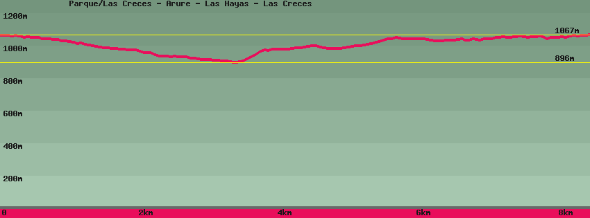
Parque/Las Creces - Arure - Las Hayas - Las Creces

Data sheet of the trail/hiking path 

1->2 - (GR 131) Very good shape
 ->
->
 0,57 km
  12 m
12 m  37m
37m
From the Las Creces parking area, take the track that goes deep into the forest to an old clearing for recreation. In this the forest track, on the right the path.
2->3 - () Very good shape
1,01 km 5 m 67m
Follow the path towards Arure or Las Hayas inside the forest. The path, very pleasant, is practically flat. Junction for Arure on the right or Las Hayas on the left,
3->4 - () Dirt road
1,55 km 5 m 92m
Continue on Arure in the forest then pass vineyards. Then again vineyards and an intersection: straight ahead towards Arure and on the left Las Hayas.
4->5 - () Very good shape
0,74 km 86 m 4m
Take towards Las Hayas and go up in the forest to a track on the left Las Hayas and on the right Arure.
5->6 - () Dirt road
1,03 km 48 m 20m
Follow the track towards Las Hayas to the village and go up the road to arrive in front of the Ifigenia restaurant. Straight the road continues in the direction of Valle Gran Rey and El Cercado. On the left it goes up towards the park and Las Cresses.
6->7 - (GR 131) Very good shape
0,80 km 45 m 14m
Go up the road to Las Cresses on 20m and leave it for a dirt road in the middle of houses up to the chapel. Follow the path to the left of the chapel and enter the heather forest. Arrived on the track, it continues on the right towards Las Cresses and the general road. Straight ahead, a path joins Las Cresses or Arure.
7->8 - (GR 131) Dirt road
1,70 km 58 m 51m
Follow the track towards Las Cresses. Arrived on the old rest area of Las Cresses, the track continues straight towards the general road, on the left the path joins Las Hayas or Arure.
8->9 - (GR 131) Very good shape
0,57 km 37 m 12m
Join the main road and the car park.
Feedback(0) 
Fotos de la ruta
Recommendation for hiking:
Consult previously the state of the hiking paths with the Cabildo