Hikes of
La Gomera


Treks La Gomera
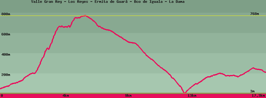
Valle Gran Rey - Los Reyes - Ermita de Guará - Bco de Iguala - La Dama

Data sheet of the trail/hiking path 

1->2 - (GR 132) Very good shape
 ->
->
 1,87 km
  147 m
147 m  5m
5m
Go up the main road along the barranco opposite the taxi rank and the town hall. Cross the river to leave the road and go up along the depots of the town hall towards the chapel of Los Reyes. You can reach it by taking a small path which goes up on the right when the track recrosses the bed of the river or follow the track and then take the stairs which go up to the chapel.
2->3 - (GR 132) Very good shape
0,47 km 49 m 12m
After the chapel go up the path that goes up on the right side of the valley until the crossroads which is before the passage of a dry ravine with 2 houses above the path. Right towards Chipude/El Cercado/Ermita de Guará. Straight the path goes up in the valley towards the district of Chele.
3->4 - (GR 132) Good shape
1,75 km 486 m 44m
Mount towards Chipude/El Cercado, along the 2 houses. The climb is steep but the view magnificent (1 hour). At the pass, a dead-end path heads off to the right to reach a flat area which dominates Valle Gran rey and the Gerián/Argaga Valley. On the left Chipude/El Cercado.
4->5 - (GR 132) Very good shape
0,97 km 115 m 33m
Continue towards Chipude/El Cercado, descend into the barranco and go up opposite to join the canal. On the right the chapel of Guará and Gerián. On the left Chipude/El Cercado.
5->6 - (GR 132) Very good shape
0,38 km 16 m 8m
Follow the canal (instead of going up the path) to the chapel.
6->7 - (GR 132) Very good shape
0,30 km 15 m 2m
Go up the paved road which arrives at the Hermitage for 200m until the path crosses.
7->8 - (GR 132) Very good shape
0,69 km 0 m 77m
8->9 - (GR 132) Very good shape
5,66 km 8 m 696m
9->10 - (GR 132) Very good shape
2,49 km 209 m 26m
10->11 - (GR 132) Very good shape
2,75 km 102 m 81m
Feedback(0) 
Fotos de la ruta
Recommendation for hiking:
Consult previously the state of the hiking paths with the Cabildo