Hikes of
La Gomera


Treks La Gomera
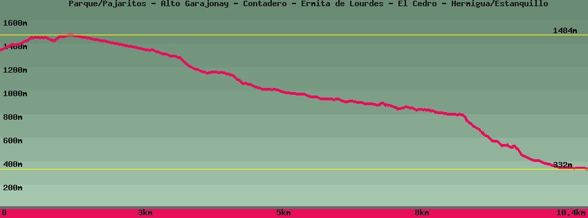
Parque/Pajaritos - Alto Garajonay - Contadero - Ermita de Lourdes - El Cedro - Hermigua/Estanquillo

Data sheet of the trail/hiking path 

1->2 - (GR 131) Very good shape
 ->
->
 0,58 km
  112 m
112 m  7m
7m
In front of the Pajaritos car park, cross the roundabout and take the track indicated alto de Garajonay for a few meters . Leave it on the right towards el Alto de Garajonay then climb through the heather. Arrived on a flat on the right a path descends towards the parking lot of the Contadero. Straight towards the summit (Alto de Garajonay).
2->3 - (GR 131) Very good shape
0,16 km 17 m 2m
Follow towards the summit in the middle of low vegetation resulting from the fire of 2012 and go down again until the crossing on the right towards the Contadero, on the left towards Igualero and all straight towards the summit (Alto de Garajonay.
3->4 - (GR 131) Very good shape
0,08 km 0 m 12m
Go up to the top of Garajonay. On the opposite side of the esplanade, a cemented track goes down to the Contadero parking lot.
4->5 - (GR 131) Very good shape
0,28 km 40 m 0m
5->6 - (GR 131) Dirt road
0,53 km 0 m 52m
Go down the cement track towards Contadero. Further down is a crossroads. On the left, a dirt track joins Chipude and El Cercado, a path on the right returns to the summit of Garajonay and the cement track continues downhill towards the Contadero.
6->7 - () Dirt road
0,43 km 0 m 41m
Go down a little further on the track On the right a path goes up towards the summit of Garajonay.
7->8 - () Dirt road
0,40 km 0 m 39m
Go down the cemented track towards Contadero. Arrived on the main road, cross. Opposite at the bottom of the parking lot starts the path that descends to Las Mimbreras, El Cedro and the Hermitage of Lourdes.
8->9 - () Very good shape
2,46 km 22 m 389m
Down towards Las Mimbreras to the Campamiento viejo. Right or left Las Mimbreras.
9->10 - () Very good shape
0,63 km 0 m 52m
Descend towards Las Mimbreras in the middle of the forest until you reach the dirt track which leads on the left to Los Aceviños and on the right towards the Main road ( dorsal carretera). Opposite, from the car park down the path to the Ermita de Lourdes and Le Cedro.
10->11 - () Very good shape
0,46 km 2 m 29m
Go down towards the chapel of Nuestra Señora de Lourdes. The path follows the stream, then a small wooden bridge allows you to cross it to reach the chapel. In front of it, on the right, the 'policy path' leads to the paved Cedro road. Straight on the path continues to descend towards the hamlet of Cedro.
11->12 - () Very good shape
1,03 km 36 m 77m
Down towards the hamlet of Cedro through the forest to a small group of houses including the old school of Cedro. On the right, a path goes up towards the road and the Aula de la Naturaleza. Straight to the village.
12->13 - () Very good shape
0,62 km 3 m 53m
Continue down towards the village of Cedro. Arrived on the paved track, turn right towards the village and head towards the picnic area by the stream, follow it and go up to the La Vista bar, on the left or follow the stream to descend towards Hermigua along the waterfall.
13->14 - () Very good shape
1,31 km 31 m 306m
Down along the stream and below the Cedro campsite, managed by Bar La Vista (located at -above). From the electric pylon begins the steep descent along the waterfall towards Hermigua. The stream pauses at the los Tiles dam. Go down the stairs and cross over the small bridge. To the right, the path by a staircase joins a dirt track that leads to the main road GM1 above the dam da Mulagua (Hermigua). On the left the path continues to descend along the valley towards Hermigua.
14->15 - () Very good shape
1,46 km 29 m 237m
Feedback(0) 
Fotos de la ruta
Recommendation for hiking:
Consult previously the state of the hiking paths with the Cabildo